
Account
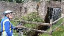
Pictures
T2013-
Tandem Club GPX/TCX Rides list
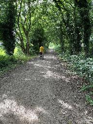
As a club we have many organised rides including national and international large events as well as local regional group rides. Quite a few of these have been made available to members using route sheets and more recently GPX/TCX files for sat navs. This is a database of all of these rides allowing you to view and download GPX/TCX files and route sheets where available.
We are slowly adding all of our rides to this database. If any member is willing to help that would be great ! These rides are provided on an as is basis if you ride them you do so entirely at your own risk. The Club, its officers and ride organisers accept no responsibility for loss, damage to property, accident, injury or death, that may occur, however caused, whether by negligence, deliberate act or otherwise. Any RO/member can add rides to make it easy for members to access them.
You can add rides using the Add Ride link. You must have a website login account to do this.By default the Selection criteria will be for rides in your own group. Set this to "All" to list all rides and click on the "Search" button. Some assistance with using this system is at: Help. You can just view and add places of interest using PlaceList. Note that when you have added a ride you can view it with a background map and proceed to add places of interest. This system is still a work in progress. Please feedback issues/ideas to: webgroup@tandem-club.org.uk.
We have just added all of the BCQ's to the system. See BCQ's
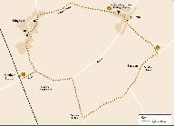
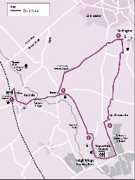
 | Id: 1258, Quality: 5Group: PublishedRouteLocation: Market HarboroughPostcode: LE16 7DTMap Reference: 52.4788, -0.91012Ride length: 27 kmRide ease: EasyAdded by: Neil Wheadon | See https://www.sustrans.org.uk/find-a-route-on-the-national-cycle-network/brampton-valley-way/ Start at Market Harborough Station, St Mary's Rd, Market Harborough LE16 7DT SURFACE:- The Brampton Valley Way spans over 14 miles between Northampton and Market Harborough, what was once a disused railwa ... |
 | Id: 1122, Quality: 5Group: PublishedRouteLocation: HaverfordwestPostcode: SA61 1TPMap Reference: 51.8016, -4.96537Ride length: 42 kmRide ease: HardAdded by: Neil Wheadon | See https://www.pembrokeshire.gov.uk/cycle-pembrokeshire/cycle-pembrokeshire-wizo-trail Trave/map icon at https://tandem-club.org.uk/rides?cmd=placeView&id=10303 This was manually written up using RidewithGPS (with care) as no GPX was available. The Trail meanders through part of the central area of ... |
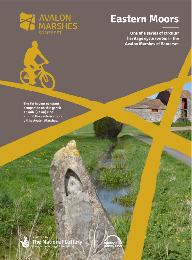 | Id: 715, Quality: 5Group: PublishedRouteLocation: GlastonburyPostcode: BA8 8LZMap Reference: 51.1406, -2.7074Ride length: 23 kmRide ease: EasyAdded by: Neil Wheadon | see Avalon Eastern Moors Ride https://avalonmarshes.org/explore/things-to-do/cycling/ This route explores the eastern marshes including Queen's Sedge Moor, Hearty Moor, Kennard Moor and the green fringes of the Isle of Avalon. |
 | Id: 616, Quality: 5Group: PublishedRouteLocation: Sturminster NewtonPostcode: DT10 1BNMap Reference: 50.9269, -2.30266Ride length: 20 kmRide ease: EasyAdded by: Neil Wheadon | This is the correct way that the North Dorset trailway runs (unlike the most popular Google search that is wrong on both ends, the path does not extend north of Sturminster Newton) Details at northdorsettrailway.org.uk The North Dorset Trailway now extends approximately 14 miles from Sturminster New ... |
 | Id: 1548, Quality: 4Group: PublishedRouteLocation: KinghamPostcode: OX7 6UPMap Reference: 51.9016, -1.6283Ride length: 30 kmAdded by: Neil Wheadon | Start at Kingham Station, Station Rd, Kingham, Chipping Norton OX7 6UP See https://www.cotswolds-nl.org.uk/exploring/cycle-route/ancient-stones-old-manors/ Cycle routes from Kingham Station Cycle Route 5: Ancient Stones & Old Manors A chance to visit both Chastleton House, the Rollright Stones and d ... |
 | Id: 1547, Quality: 4Group: PublishedRouteLocation: BA3 5LSPostcode: BA3 5LSMap Reference: 52.0139, -1.51613Ride length: 24 kmRide ease: HardAdded by: Neil Wheadon | Start at See https://www.cotswolds-nl.org.uk/exploring/cycle-route/brailes-hill-and-ascot/ This is a ride of tracks and vistas. It takes you around the Vale of Feldon by riding over the Ironstone Hills and around Brailes Hill. The views are great and the tracks are good though largely soft and un-su ... |
 | Id: 1546, Quality: 4Group: PublishedRouteLocation: KinghamPostcode: OX7 6UPMap Reference: 51.9016, -1.62813Ride length: 22 kmAdded by: Neil Wheadon | Start at Kingham Station, Station Rd, Kingham, Chipping Norton OX7 6UP See https://www.cotswolds-nl.org.uk/exploring/cycle-route/bruern-to-foxholes-nature-reserve/ A delightful short tour through Cotswold border villages, passing the site of an ancient abbey and visiting a beautiful secluded Wildlif ... |
 | Id: 1545, Quality: 4Group: PublishedRouteLocation: KinghamPostcode: OX7 6UPMap Reference: 51.9015, -1.62894Ride length: 41 kmAdded by: Neil Wheadon | Start at Kingham Station, Station Rd, Kingham, Chipping Norton OX7 6UP See https://www.cotswolds-nl.org.uk/exploring/cycle-route/burford-the-windrush-valley/ A classic Cotswolds tour across wold and along valley. Explore Widford Church and the histories of the Fettiplaces, the Mitford Sisters, and t ... |
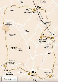
 | Id: 1544, Quality: 4Group: PublishedRouteLocation: BA3 5LSPostcode: BA3 5LSMap Reference: 51.9022, -1.62879Ride length: 42 kmAdded by: Neil Wheadon | Start at Kingham Station, Station Rd, Kingham, Chipping Norton OX7 6UP See https://www.cotswolds-nl.org.uk/exploring/cycle-route/charlbury-and-wychwood-forest/ A medium distance ride on quiet lanes passing through the ancient Wychwood Forest area and past a restored Cotswold sheepwash. Catch the tra ... |
 | Id: 1543, Quality: 4Group: PublishedRouteLocation: GosportPostcode: PO13 0EWMap Reference: 50.8122, -1.1602Ride length: 4 kmRide ease: EasyAdded by: Neil Wheadon | Start at Gosport PO13 0EW See https://www.hants.gov.uk/transport/transportschemes/brtphaseII The Eclipse Busway provides a priority public transport route connecting Fareham in the north to Gosport in the south. The existing route, completed in 2012, is largely off-road with a dedicated section foll ... |
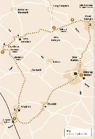
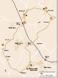
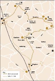 | Id: 1539, Quality: 4Group: PublishedRouteLocation: KinghamPostcode: OX7 6UPMap Reference: 51.9017, -1.62795Ride length: 45 kmAdded by: Neil Wheadon | Start at Kingham Station, Station Rd, Kingham, Chipping Norton OX7 6UP See https://www.cotswolds-nl.org.uk/wp/wp-content/uploads/2025/01/Moreton-in-Marsh.pdf See https://www.cotswolds-nl.org.uk/exploring/cycle-route/moreton-in-marsh-and-the-rollright-stones/ This is a great route up over Chastleton ... |
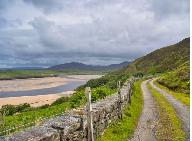 | Id: 1536, Quality: 4Group: PublishedRouteLocation: DurnessPostcode: IV27 4PZMap Reference: 58.5685, -4.74381Ride length: 23 kmAdded by: Neil Wheadon | Start at Durness, Sutherland, IV27 4PZ See https://www.venture-north.co.uk/about/itineraries/cycling-in-the-far-north Source https://www.venture-north.co.uk/things-to-do/walking-cycling/cycling Sutherland Council have a page for cycling, so I have taken this and created a GPX file It's not easy to a ... |
 | Id: 1535, Quality: 4Group: PublishedRouteLocation: LairgPostcode: IV27 4DBMap Reference: 58.0233, -4.3954Ride length: 35 kmAdded by: Neil Wheadon | Start at Main Street, Lairg IV27 4DB This is the best that Sutherland Council can come up with. I have created the GPX from the description on their website https://www.venture-north.co.uk/about/itineraries/cycling-in-the-far-north This half-day route, including time to explore on foot, starts and e ... |
 | Id: 1534, Quality: 4Group: PublishedRouteLocation: NorthleachPostcode: GL54 3JHMap Reference: 51.833, -1.84297Ride length: 28 kmRide ease: HardAdded by: Neil Wheadon | Start at The Old Prison, A429, Fosse Way, Northleach, Cheltenham GL54 3JH See https://www.cotswolds-nl.org.uk/exploring/cycle-route/northleach-and-hazleton/ This ride takes you around the high wold with its open fields and secret valleys. It also dips down into the upper Leach and Coln valleys givin ... |
 | Id: 1533, Quality: 4Group: PublishedRouteLocation: KinghamPostcode: OX7 6UPMap Reference: 51.9017, -1.6279Ride length: 11 kmRide ease: EasyAdded by: Neil Wheadon | Start at Kingham Station, Station Rd, Kingham, Chipping Norton OX7 6UP See https://www.cotswolds-nl.org.uk/wp/wp-content/uploads/2025/01/Sarsden-Circuit.pdf See https://www.cotswolds-nl.org.uk/exploring/cycle-route/sarsden-circuit/ A short easy ride through the Evenlode Valley passing quiet Cotswold ... |
 | Id: 1532, Quality: 4Group: PublishedRouteLocation: BA3 5LSPostcode: BA3 5LSMap Reference: 52.0051, -1.87979Ride length: 19 kmAdded by: Neil Wheadon | Start at See https://www.cotswolds-nl.org.uk/wp/wp-content/uploads/2025/01/Snowshill-and-Beyond.pdf Cotswolds National Landscape Cotswold Business Centre, 2 A P Ellis Road, Upper Rissington, Glos. GL54 2QB Tel: 07841 663607. www.cotswolds-nl.org.uk This ride shows you some of the Cotswolds many face ... |
 | Id: 1531, Quality: 4Group: PublishedRouteLocation: BA3 5LSPostcode: BA3 5LSMap Reference: 52.5961, -1.97721Ride length: 8 kmAdded by: Neil Wheadon | Start at See http://backthetrack.org.uk/ Excellent Resource |
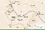
 | Id: 1530, Quality: 4Group: PublishedRouteLocation: KemblePostcode: GL7 6AWMap Reference: 51.6773, -2.02294Ride length: 51 kmAdded by: Neil Wheadon | Start at Kemble Railway Station, Kemble, Cirencester GL7 6AW See https://www.cotswolds-nl.org.uk/wp/wp-content/uploads/2025/01/3.-Tetbury-and-Westonbirt.pdf Medium or hard ride through Cotswold villages, past churches and pubs, visiting the old market town of Tetbury. An additional loop visits the w ... |
 | Id: 1529, Quality: 4Group: PublishedRouteLocation: KemblePostcode: GL7 6AWMap Reference: 51.6776, -2.02252Ride length: 18 kmRide ease: EasyAdded by: Neil Wheadon | Start at Kemble Railway Station, Kemble, Cirencester GL7 6AW See https://www.cotswolds-nl.org.uk/wp/wp-content/uploads/2025/01/1.-The-Infant-Thames.pdf An easy ride through quiet villages into the Cotswold Water Park; passing country pubs country parks and close to the source of the magnificent Rive ... |
 | Id: 1527, Quality: 4Group: PublishedRouteLocation: KemblePostcode: GL7 6AWMap Reference: 51.6775, -2.0227Ride length: 24 kmAdded by: Neil Wheadon | Start at Kemble Railway Station, Kemble, Cirencester GL7 6AW See https://www.cotswolds-nl.org.uk/wp/wp-content/uploads/2025/01/2.-Trains-Boats-and-Planes.pdf This easy 16 mile ride takes you to one of the wonders of the canal building age - the Sapperton Tunnel on the Thames & Severn Canal. This is ... |
 | Id: 1526, Quality: 4Group: PublishedRouteLocation: KinghamPostcode: OX7 6UPMap Reference: 51.9022, -1.62879Ride length: 60 kmRide ease: HardAdded by: Neil Wheadon | Start at Kingham Railway Station, Station Rd, Kingham, Chipping Norton OX7 6UP See https://www.cotswolds-nl.org.uk/exploring/cycle-route/wildlife-hillforts-halls/ A long day ride for the cycling enthusiast, up and over the Evenlode Valley passing historic houses and villages and dropping into the Wi ... |
 | Id: 1525, Quality: 4Group: PublishedRouteLocation: KinghamPostcode: OX7 6UPMap Reference: 51.9021, -1.62882Ride length: 43 kmRide ease: AverageAdded by: Neil Wheadon | Start at Kingham Railway Station, Station Rd, Kingham, Chipping Norton OX7 6UP See https://www.cotswolds-nl.org.uk/wp/wp-content/uploads/2017/06/bourton-bulls-and-beer.pdf An interesting day ride visiting the Cotswold Farm Park via Bourton-on-the Water, the Venice of the Cotswolds. There are plenty ... |
 | Id: 1524, Quality: 4Group: PublishedRouteLocation: KinghamPostcode: OX7 6UPMap Reference: 51.9023, -1.62879Ride length: 41 kmAdded by: Neil Wheadon | Start at Kingham Railway Station, Station Rd, Kingham, Chipping Norton OX7 6UP See https://www.boltholeretreats.co.uk/wp-content/uploads/2021/05/Ride_AONBRoute06KinghamBurfordWindrushValley.pdf A classic Cotswolds tour across wold and along valley. Explore Widford Church and the histories of the Fet ... |
 | Id: 1523, Quality: 4Group: PublishedRouteLocation: Lostock GralamPostcode: CW9 7NUMap Reference: 53.2676, -2.46459Ride length: 31 kmRide ease: EasyAdded by: Neil Wheadon | Start at Lostock Gralam Station, Station Rd, Lostock Gralam, Cheshire CW9 7NU See https://visitcheshire.com/trails/jodrell-cycle-jaunt This is a 20 mile route on quiet country roads but crossing several busy main roads. It starts at Lostock Gralam Station the and passes Jodrell Bank Visitor Centre ( ... |
 | Id: 1521, Quality: 4Group: PublishedRouteLocation: MarplePostcode: SK6 6HUMap Reference: 53.3964, -2.07798Ride length: 16 kmRide ease: EasyAdded by: Neil Wheadon | Start near Rose Hill Marple Station, 1 Railway Rd, Marple, Stockport SK6 6HU See https://visitcheshire.com/trails/middlewood-way The Middlewood Way is a 16km (10 mile) linear country park following the former Macclesfield, Bollington and Marple Railway through picturesque Cheshire East countryside. ... |
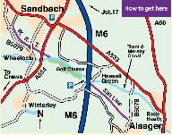 | Id: 1520, Quality: 4Group: PublishedRouteLocation: ElworthPostcode: CW11 3HDMap Reference: 53.1403, -2.38925Ride length: 2 kmRide ease: EasyAdded by: Neil Wheadon | Start at Elworth CW11 3HD See https://visitcheshire.com/trails/wheelock-rail-trail-and-salt-line A 2.5 km / 1 1/2 mile long multi-user trail for walkers, cyclists and horse riders. Formerly a branch line of the North Staffordshire Railway. A mainly wooded trail running through farmland and other woo ... |
 | Id: 1519, Quality: 4Group: PublishedRouteLocation: CuddingtonPostcode: CW8 2TDMap Reference: 53.236, -2.61283Ride length: 9 kmAdded by: Neil Wheadon | Start at the end of Waste Ln, Cuddington, Northwich CW8 2TD See https://visitcheshire.com/trails/the-whitegate-way Welcome to Whitegate Way, where heavy goods trains laden with salt once lumbered to Cuddington to join the Chester - Manchester line. Today the old railway line has been transformed and ... |
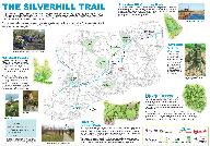 | Id: 1517, Quality: 4Group: PublishedRouteLocation: AlfretonPostcode: DE55 5JJMap Reference: 53.1255, -1.36349Ride length: 6 kmRide ease: EasyAdded by: Neil Wheadon | Start at Gloves Lane, Alfreton DE55 5JJ See https://www.derbyshire.gov.uk/site-elements/documents/pdf/leisure/countryside/access/walking/silverhill-trail-route-map.pdf The Silverhill Trail was developed on a former mineral railway that once served Silverhill Colliery. You can enjoy the 4.5 mile Silv ... |
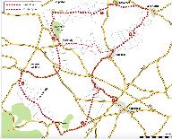
 | Id: 1515, Quality: 4Group: PublishedRouteLocation: HawesPostcode: DL8 3RQMap Reference: 54.3035, -2.2006Ride length: 87 kmRide ease: HardAdded by: Neil Wheadon | Gayle Lane Car Park, Gayle Ln, Hawes DL8 3RQ See https://cyclethedales.org.uk/route/tan_hill_toughie/ This is a tough road ride starting in Hawes where there is a good range of accommodation, cafes, shops and attractions. Based at the Dales Countryside Museum site is Stage 1 Cycles and the Firebox C ... |
 | Id: 1514, Quality: 4Group: PublishedRouteLocation: SettlePostcode: BD24 9EDMap Reference: 54.0688, -2.27714Ride length: 28 kmRide ease: AverageAdded by: Neil Wheadon | Start in the Market Pl, Settle BD24 9ED See https://cyclethedales.org.uk/route/settle_circular/ A gentle, yet spectacular circuit, passing through some of the best-known villages in the southern Dales. A gradual climb onto Swarth Moor, provides excellent views of Pen-y-ghent; before a pleasant desce ... |
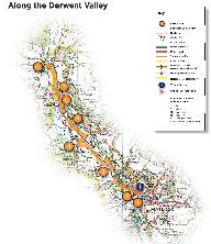 | Id: 1513, Quality: 4Group: PublishedRouteLocation: MatlockPostcode: DE4 3NAMap Reference: 53.1383, -1.55725Ride length: 8 kmRide ease: EasyAdded by: Neil Wheadon | Start at Matlock Station, Matlock DE4 3NA See https://visitpeakdistrict.com/trails/matlock-cycle-routes-along-the-derwent-valley The GPX from this does not work. The instructions are detailed but I can't quite see how they work remotely. 1. With the station on your left, follow the on pavement cycle ... |
 | Id: 1512, Quality: 4Group: PublishedRouteLocation: HayfieldPostcode: SK22 2JEMap Reference: 53.3796, -1.9454Ride length: 28 kmAdded by: Neil Wheadon | Start on the bridge over the river Sett in Hayfield, High Peak SK22 2JE See https://visitpeakdistrict.com/trails/hayfield-to-whaley-bridge-high-peak-road-cycling-route Passing through the vibrant High Peak towns of New Mills and Whaley Bridge, where there are numerous options for coffee stops and re ... |
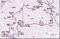
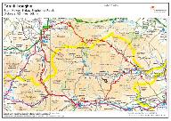
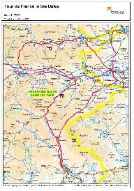 | Id: 1510, Quality: 4Group: PublishedRouteLocation: GrassingtonPostcode: BD23 5LBMap Reference: 54.0717, -1.99898Ride length: 123 kmRide ease: HardAdded by: Neil Wheadon | Start at Grassington National Park Centre, Hebden Rd, Grassington, Skipton BD23 5LB See https://cyclethedales.org.uk/route/tour_de_france_in_the_dales/ The Tour de France came to the Yorkshire Dales in 2014 and this route takes in the best of the Stage 1 route including all of the three climbs - Cot ... |
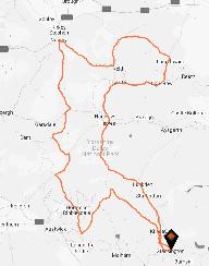 | Id: 1509, Quality: 4Group: PublishedRouteLocation: GrassingtonPostcode: BD23 5LBMap Reference: 54.0699, -1.99643Ride length: 176 kmRide ease: HardAdded by: Neil Wheadon | Start at Grassington National Park Centre, Hebden Rd, Grassington, Skipton BD23 5LB See https://cyclethedales.org.uk/route/etape_du_dales/ The Etape du Dales is a cyclosportive event held each May. This is a long route involving seven main challenging climbs and descents. Make sure you and your bike ... |
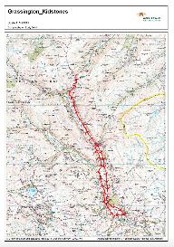 | Id: 1508, Quality: 4Group: PublishedRouteLocation: GrassingtonPostcode: BD23 5LBMap Reference: 54.0696, -1.9968Ride length: 42 kmRide ease: HardAdded by: Neil Wheadon | Start at Grassington National Park Centre, Hebden Rd, Grassington, Skipton BD23 5LB See https://cyclethedales.org.uk/route/kidstones_pass/ The Tour de France in 2014 was quite an event and taking on one or more of the climbs in the Yorkshire Dales is on many peoples' tick list. This route takes you ... |
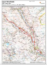 | Id: 1507, Quality: 4Group: PublishedRouteLocation: GrassingtonPostcode: BD23 5LBMap Reference: 54.0696, -1.99678Ride length: 39 kmRide ease: EasyAdded by: Neil Wheadon | Start at Grassington National Park Centre, Hebden Rd, Grassington, Skipton BD23 5LB See https://cyclethedales.org.uk/route/upper_wharfedale/ The upper Wharfedale valley provides great limestone scenery and lovely stone built villages with plenty of opportunities for a break. There are lots of option ... |
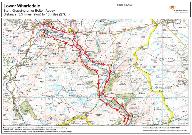 | Id: 1506, Quality: 4Group: PublishedRouteLocation: GrassingtonPostcode: BD23 5LBMap Reference: 54.0697, -1.99677Ride length: 30 kmRide ease: EasyAdded by: Neil Wheadon | Start at Grassington National Park Centre, Hebden Rd, Grassington, Skipton BD23 5LB See https://cyclethedales.org.uk/route/lower_wharfedale/ Wharfedale is a popular valley at the southern end of the National Park. This route follows the valley between Grassington and Bolton Abbey using the roads on ... |
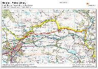
 | Id: 1505, Quality: 4Group: PublishedRouteLocation: SkiptonPostcode: BD23 1AHMap Reference: 53.9624, -2.01635Ride length: 46 kmAdded by: Neil Wheadon | Skipton Town Hall, High St, Skipton BD23 1AH See https://cyclethedales.org.uk/route/into_wharfedale/ The route starts in Skipton - a well known large market town with its many attractions. This is quickly left behind and a quiet road takes you from Embsay to the well known Bolton Abbey. From here we ... |
 | Id: 1504, Quality: 4Group: PublishedRouteLocation: SkiptonPostcode: BD23 1AHMap Reference: 53.9625, -2.0163Ride length: 10 kmAdded by: Neil Wheadon | Start at Skipton Town Hall, High St, Skipton BD23 1AH See https://cyclethedales.org.uk/route/skipton_to_bolton_abbey/ The back road from Skipton to Bolton Abbey is a justifiably popular cycling road. Skipton is a busy and popular market town with plenty of things to see and do. The route goes from h ... |
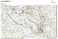
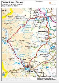 | Id: 1503, Quality: 4Group: PublishedRouteLocation: Pateley BridgePostcode: HG3 5HLMap Reference: 54.0855, -1.76105Ride length: 49 kmRide ease: HardAdded by: Neil Wheadon | Start at the bridge in Pateley Bridge Harrogate HG3 5HL See https://cyclethedales.org.uk/route/pateley_bridge_to_masham/ The starting point for this route is Pateley Bridge - a great little town in upper Nidderdale. There is no warm up on this ride as it heads straight up a steep, tough climb out of ... |
 | Id: 1502, Quality: 4Group: PublishedRouteLocation: AshbournePostcode: DE6 1RRMap Reference: 53.0131, -1.73765Ride length: 22 kmRide ease: EasyAdded by: Neil Wheadon | Start at Leisure Way, Clifton Rd, Ashbourne DE6 1RR See https://visitpeakdistrict.com/trails/tissington-trail Another PDF Map at https://dc-peakdistrict.files.svdcdn.com/production/assets/images/PDNP-White-Peak-Trails-Map-1.pdf?dm=1730966843 See https://www.sustrans.org.uk/find-a-route-on-the-nation ... |
 | Id: 1500, Quality: 4Group: PublishedRouteLocation: BA3 5LSPostcode: BA3 5LSMap Reference: 54.3043, -2.19408Ride length: 74 kmRide ease: HardAdded by: Neil Wheadon | |
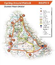 | Id: 1499, Quality: 4Group: PublishedRouteLocation: MatlockPostcode: DE4 3NAMap Reference: 53.1381, -1.5573Ride length: 23 kmRide ease: HardAdded by: Neil Wheadon | Start from Matlock Station, Matlock DE4 3NA See https://visitpeakdistrict.com/trails/matlock-cycle-routes-stanton-moor-circular The GPX does not work from the council site, so has been redone for Rides Testing climbs and superb views over the Wye Valley. This route is available to download as a PDF ... |
 | Id: 1498, Quality: 4Group: PublishedRouteLocation: Middleton Top visitor centrePostcode: DE4 4LSMap Reference: 53.0929, -1.59076Ride length: 33 kmAdded by: Neil Wheadon | Start at Middleton Top visitor centre and cycle hire DE4 4LS See https://visitpeakdistrict.com/trails/biking-and-birdsong-around-carsington-cycle-route The GPX download doesn't work, so has been created for Rides Discover a tranquil landscape shaped by lead mining and quarrying as you cycle through ... |
 | Id: 1497, Quality: 4Group: PublishedRouteLocation: Carsington Water Visitor CentrePostcode: DE6 1STMap Reference: 53.0621, -1.64088Ride length: 14 kmRide ease: EasyAdded by: Neil Wheadon | Start at Carsington Water Visitor Centre, Carsington, Ashbourne DE6 1ST See https://visitpeakdistrict.com/trails/matlock-cycle-routes-the-carsington-loop The GPX from this site oesn't work, so has been created for Rides A delightful loop of Carsington Reservoir. This route is available to download a ... |
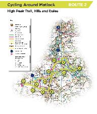 | Id: 1496, Quality: 4Group: PublishedRouteLocation: CromfordPostcode: DE4 3RQMap Reference: 53.1097, -1.55286Ride length: 14 kmAdded by: Neil Wheadon | Cromford Wharf Car park, 2 Mill Rd, Cromford, Matlock DE4 3RQ See https://visitpeakdistrict.com/trails/matlock-cycle-routes-high-peak-trail-hills-and-dales The GPX does not work on the download, I have recreated this as best I can here Start/End Point: Cromford Wharf car park DE4 3RP Distance: 15km/ ... |
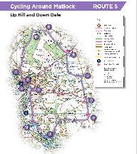 | Id: 1495, Quality: 4Group: PublishedRouteLocation: MatlockPostcode: DE4 3NAMap Reference: 53.1382, -1.55833Ride length: 24 kmAdded by: Neil Wheadon | Start from Matlock Station, Matlock DE4 3NA See https://visitpeakdistrict.com/trails/matlock-cycle-routes-up-hill-and-down-dale Discover a landscape full of heritage with breathtaking views. This route is available to download as a PDF and GPX file at the bottom of this page. Start/End Point: Matloc ... |
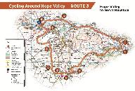 | Id: 1494, Quality: 4Group: PublishedRouteLocation: Hathersage StationPostcode: S32 1DTMap Reference: 53.3264, -1.65233Ride length: 28 kmRide ease: HardAdded by: Neil Wheadon | Start Hathersage station S32 1DT See https://visitpeakdistrict.com/trails/hope-valley-cycle-routes-hope-valley-to-great-hucklow The web ource has a GPX that doesn't work so created here A 17.5 mile journey through moorland landscapes. This route is available to download as a PDF and GPX file at the ... |
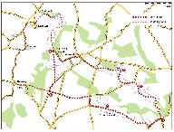
 | Id: 1493, Quality: 4Group: PublishedRouteLocation: Hassop StationPostcode: DE45 1NWMap Reference: 53.2313, -1.67582Ride length: 43 kmAdded by: Neil Wheadon | Start at Hassop Station, Hassop Rd, Bakewell DE45 1NW See https://visitpeakdistrict.com/trails/stately-homes-and-standing-stones-cycle-route There is no GPX for this from the webste, but has been created for Rides Step 1 Start from Hassop or Bakewell former stations on the Monsal Trail. Passing thro ... |
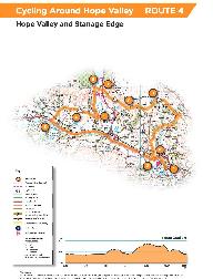 | Id: 1492, Quality: 4Group: PublishedRouteLocation: HathersagePostcode: S32 1DTMap Reference: 53.3261, -1.65169Ride length: 20 kmRide ease: HardAdded by: Neil Wheadon | Start at Hathersage Station, Back Ln, Hathersage, Hope Valley S32 1DT See https://visitpeakdistrict.com/trails/hope-valley-cycle-routes-hope-valley-and-stanage-edge The GPX from this site does not work, I've redone it and it's here Experience Dark Peak villages and gritstone edges on this 13 mile cy ... |